The Indus River (Sanskrit: Sindhu; Urdu: سندھ; Sindhi: سنڌو Sindhu; Punjabi: سندھ Sindh;Hindko: سندھ Sindh; Tamil: சிந்து நதி Sindhu nadhi; Avestan: Harahuti; Pashto: اباسينAbāsin "Water of Sindh"; Arabic Al-Sind; Wylie:Sênggê Zangbo "Lion River"; pinyin: Sēngé Zàngbù/Shīquán Hé/Yìndù Hé; Greek: Ινδός Indós; Turki: Nilab) is a major river which flows through the full length of Pakistan.
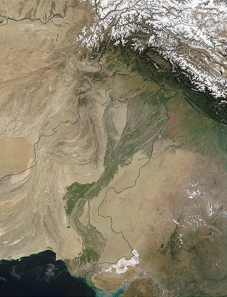
Originating in the Tibetan plateau of western China in the vicinity of Lake Mansarovar inTibet Autonomous Region, the river runs a course through the Ladakh district of Jammu and Kashmir and then enters Pakistan via the Northern Areas (Gilgit-Baltistan), flowing through the North in a southerly direction along the entire length of Pakistan, to merge into the Arabian Sea near the port city of Karachi in Sindh. The total length of the river is 3,180 kilometers (1,976 miles) and it is Pakistan's longest river.
The river has a total drainage area exceeding 1,165,000 square kilometers (450,000 square miles). The river's estimated annual flow stands at around 207 cubic kilometers, making it the twenty-first largest river in the world in terms of annual flow. Beginning at the heights of the world with glaciers, the river feeds the ecosystem of temperate forests, plains and arid countryside. Together with the rivers Jhelum, Chenab, Ravi,Sutlej, Beas and two tributaries from the Khyber Pakhtunkhwa and Afghanistan, the Indus forms the Sapta Sindhu (Seven Rivers) delta of Pakistan.
Description:
The Indus provides the key water resources for the economy of Pakistan - especially the Breadbasket of Punjab province, which accounts for most of the nation's agricultural production, and Sindh. The word Punjab is a \ word panj meaning Five, and āb meaning Water, giving the literal meaning of the Land of the Five Rivers. The Five rivers after which Punjab is named are the Jhelum, Chenab, Ravi, Beas and the Sutlej. The river also supports many heavy industries and provides the main supply of potable water in Pakistan.
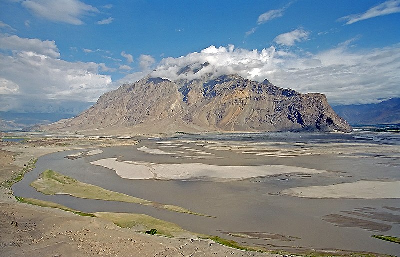
The ultimate source of the Indus is in Tibet; it begins at the confluence of the Sengge and Gar rivers that drain the Nganglong Kangri and Gangdise Shan mountain ranges. The Indus then flows northwest through Ladakh and Baltistan into Gilgit, just south of the Karakoram range. The Shyok River, Shigar and Gilgit streams carry glacial waters into the main river. It gradually bends to the south, coming out of the hills between Peshawar and Rawalpindi. The Indus passes gigantic gorges 4,500-5,200 meters (15,000-17,000 feet) deep near the Nanga Parbat massif. It flows swiftly across Hazara, and is dammed at the Tarbela Reservoir. The Kabul River joins it near Attock. The remainder of its route to the sea is in plains of the Punjab and Sindh, and the river becomes slow-flowing and highly braided. It is joined by Panjnad River at Mithankot. Beyond this confluence, the river, at one time, was named Satnad River (Sat = seven, Nadi = river), as the river was now carrying the waters of the Kabul River, the Indus River and the five Punjab rivers. Passing by Jamshoro, it ends in a large delta to the east of Thatta.
The Indus is one of the few rivers in the world that exhibit a tidal bore. The Indus system is largely fed by the snows and glaciers of the Himalayas, Karakoram and the Hindu Kush ranges of Tibet, the state of Jammu and Kashmir and the Northern Areas of Pakistan respectively. The flow of the river is also determined by the seasons - it diminishes greatly in the winter, while flooding its banks in the monsoon months from July to September. There is also evidence of a steady shift in the course of the river since prehistoric times - it deviated westwards from flowing into the Rann of Kutch and adjoining Banni grasslands after the 1816 earthquake.
Effects of climate change on the river
The Tibetan Plateau contains the world's third-largest store of ice. Qin Dahe, the former head of the China Meteorological Administration, said the recent fast pace of melting and warmer temperatures will be good for agriculture and tourism in the short term, but issued a strong warning:
"Temperatures are rising four times faster than elsewhere in China, and the Tibetan glaciers are retreating at a higher speed than in any other part of the world.... In the short term, this will cause lakes to expand and bring floods and mudflows. . . . In the long run, the glaciers are vital lifelines of the Indus River. Once they vanish, water supplies in Pakistan will be in peril."
“There is [sic] insufficient data to say what will happen to the Indus,” says David Grey, the World Bank’s senior water advisor in South Asia. “But we all have very nasty fears that the flows of the Indus could be severely, severely affected by glacier melt as a consequence of climate change,” and reduced by perhaps as much as 50 percent. “Now what does that mean to a population that lives in a desert [where], without the river, there would be no life? I don’t know the answer to that question,” he says. “But we need to be concerned about that. Deeply, deeply concerned.
History:
Paleolithic sites have been discovered in Pothohar near Pakistan's capital Islamabad, with the stone tools of the Soan Culture. In ancient Gandhara, near Islamabad, evidence of cave dwellers dated 15,000 years ago has been discovered at Mardan.
The major cities of the Indus Valley Civilization, such as Harappa and Mohenjo-daro, date back to around 3300 BC, and represent some of the largest human habitations of the ancient world. The Indus Valley Civilization extended from across Pakistan, with an upward reach from east of Jhelum River to Ropar on the upper Sutlej. The coastal settlements extended from Sutkagan Dor at the Pakistan, Iran border to kutch in easternmost Pakistan. There is an Indus site on the Amu Darya at Shortughai in northern Afghanistan, and the Indus site Alamgirpur at the Hindon River is located only 28 km from Delhi. To date, over 1,052 cities and settlements have been found, mainly in the general region of the Ghaggar-Hakra River and its tributaries. Among the settlements were the major urban centers of Harappa and Mohenjo-daro, as well as Lothal, Dholavira, Ganeriwala, and Rakhigarhi. Only 90-96 of the over-800 known Indus Valley sites have been discovered on the Indus and its tributaries. The Sutlej, now a tributary of the Indus, in Harappan times flowed into the Ghaggar-Hakra River, in the watershed of which were more Harappan sites than along the Indus.
Most scholars believe that settlements of Gandhara grave culture of the early Indo-Aryans flourished in Gandhara from 1700 BC to 600 BC, when Mohenjo-daro and Harappa had already been abandoned.
The name Indus is used in Arrian's Indica for the mighty river crossed by Alexander, based on Nearchus's contemporaneous account. "Indus" is a Hellenic derivative of the Iranian Hindu, in turn derived from Sindhu, the name of the Indus in the Rigveda. The Sanskrit Sindhu generically means river, stream, ocean, probably from a root sidh meaning to keep off; Sindhu is attested 176 times in the Rigveda, 95 times in the plural, more often used in the generic meaning. Already in the Rigveda, notably in the later hymns, the meaning of the word is narrowed to refer to the Indus river in particular, for example in the list of rivers of the Nadistuti sukta. This resulted in the anomaly of a river with masculine gender: all other Rigvedic rivers are female, not just grammatically, being imagined as goddesses and compared to cows and mares yielding milk and butter.
The Indus has formed a natural boundary between the Indian Subcontinent and its frontier with the Iranian Plateau, a region which includes Pakistan's Balochistan, Khyber Pakhtunkhwa as well as Afghanistan, Tajikistan and Iran. It has been crossed by the armies of Alexander the Great - His Macedonian forces retreated along the southern course of the river at the end of the Asian campaign after conquering what is now Pakistan and joining it to the Hellenic Empire. The Indus plains have also been under the domination of the Persian empire and the Kushan empire. The Muslim armies of Muhammad bin Qasim, Mahmud of Ghazni, Mohammed Ghori, Tamerlane and Babur also crossed the river to strike into the inner regions of Punjab and further south east.
The word "India" is derived from the Indus River. In ancient times, "India" initially referred to the region of Pakistan along the eastern banks of the Indus river, but by 300 BC, Greek writers like Megasthenes applied the term to the subcontinent which extends further eastward.
The traditional source of the river is the Senge Khabab or 'Lion's Mouth', a perennial spring, not far from the sacred Mount Kailash, and is marked by a long low line of Tibetan chortens. There are several other tributaries nearby which may possibly form a longer stream than Senge Khabab, but unlike the Senger Khabab, are all dependent on snowmelt. The Zanskar River which flows into the Indus in Ladakh has a greater volume of water than the Indus itself before that point.
"That night in the tent [next to Senge Khabab] I ask Sonmatering which of the Indus tributaries which we crossed this morning is the longest. All of them, he says, start at least a day's walk away from here. The Bukhar begins near the village of Yagra. The Lamolasay's source is in a holy place: there is a monastery there. The Dorjungla is a very difficult and long walk, three days perhaps, and there are many sharp rocks; but it its water is clear and blue, hence the tributary's other name, Zom-chu, which Karma Lama translates as 'Blue Water'. The Rakmajang rises from a dark lake called the Black Sea.
One of the longest tributaries — and thus a candidate for the river's technical source — is the Kla-chu, the river we crossed yesterday by bridge. Also known as the Lungdep Chu, it flows into the Indus from the south-east, and rises a day's walk from Darchen. But Sonamtering insists that the Dorjungla is the longest of the 'three types of water' that fall into the Seng Tsanplo ['Lion River' or Indus]."
Indus River in Pictures:

Satellite image of the Indus River basin in Southern Pakistan.
Thal Canal from the Indus river, Pakistan

Confluence of Indus River. The Indus is the lower river in this picture.

Bridge on the Indus River in Pakistan

The Indus River near Skardu, Gilgit Baltistan

Indus River, Northern Pakistan

Indus River,Ladakh Jiten Mehra

Indus River, Jammu and Kashmir

Beautiful Indus River


Indus River, Sukkur, Province of Sind, Pakistan

Indus River Skardu, Beautiful Baltistan

Distribution of Indus River water: Punjab and Sindh at loggerheads
Indus River Near Leh., Leh Ladhak., India
Indus river - Ladakh (India)

Beautiful view of Indus River Pakistan
Zanskar Indus river Sangam.

No comments:
Post a Comment